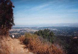
If you are wanting to do a trail & road combo in the mid distance range this is the run for you. It is a bit dangerous on some of the narrow winding roads. Cars and motorcycles like to fly through these curves and this is something you have to be aware of when you are out here. I have never had a close call but maybe that is because I am acutely aware of the dangers whereas other people may not be so aware. The route is a 14 mile loop from Wunderlich to Huddart and back. This route has 4200' of elevation gain with the high point of 2450' coming just after the halfway point. Many variations of this route could be made to make it a bit longer and a bit more difficult but this is the shortest loop possible.
This route starts at about 500' above sea level in Wunderlich Park in Woodside. Start by climbing Bear Gulch Trail located behind the horse stables at Wunderlich Park. Run that about 2.5 miles up the mountain. Next, turn right onto Alambique Trail and follow it for 2.5 miles to the top of the park at Skyline Rd (Hwy 35). This is where you leave Wunderlich Park and start to cross a combination of private and public land on the Bay Area Ridge Trail. Most of the trail is located on Cal Water land and the public has been given free use of the trail. Know normally I would stay on this trail for nearly 6 miles until I run into Huddart but this route takes a left just over a mile outside of Wunderlich. I don't know the name of the trail, it may be Madrone trail but in any case, it is not long. It brings you back up to Skyline and just across the street is a trail head for El Corte Madera OSP. Turn right and head north on Skyline Blvd. This is an easy 4 mile road run. Be sure to stop and take a look at Methuselah, an 1800 year old Redwood tree that is absolutely spectacular. Turn right onto Kings Mountain Rd and continue for a half mile until you come upon a trail on your left. This is the 9 mile mark and the entrance to Huddart Park. Run up this trail for a quarter mile and turn right onto the Archery Fire Rd. This is the quickest way to the bottom of the mountain. Stay on this Fire Rd running sharply downhill until you come out at the Miwok Picnic Area at just over 10.5 miles. Follow the road downhill and take a right at the "T" intersection. Follow this downhill and to the right towards the East Meadow Picnic Area. Turn left at the Redwood Picnic Area parking lot and continue downhill until the roads takes a sharp left. Stay running straight ahead and pick up a trail that skirts behind the meadow picnic area, across a bridge and out onto Greer Rd. Just past the 12 mile mark turn left onto Kings Mountain Rd and within 100 yds turn right onto Tripp Rd. Come back sometime and visit the historical landmark on this corner. It is awesome! Tripp Rd is about a mile long and it merges you onto Woodside Rd. Follow this for just under a mile to end the run back at the Wunderlich Park parking lot!
Click HERE for map
Showing posts with label route. Show all posts
Sunday, February 23, 2014
Saturday, April 20, 2013
Horseshoe Lake half marathon route.
A few "members" of the running group I founded, Mid Peninsula Runners, have signed up for the HorseShoe half coming up in mid-may. I have run most all of the trails around this area but not this exact route. I was excited about the idea of running "new" trails so I signed up too.
The course starts in the Skyline Ridge Open Space Preserve just off of Skyline Rd in the mountains above Palo Alto. From the main parking lot, just south of the Page Mill Rd and Skyline Rd intersection you run south along the Bay Area Ridge Trail. About 4 miles down the trail you switch to Long Ridge Trail and take it to the one and only aid station at Ward Rd. That's about 6.5 miles of running all together and then you turn around and run it back. The elevation gain over the course of this run is 1800' ft. This is pretty standard if not a little low for most of the trail halfs put on in the Bay Area so if you love trail halfs this is your course. If you haven't run many trail halfs you may find this a bit challenging but still very runnable.
| Half Marathon follows the pink route. |
Conformations and confusions; an update to the Horseshoe Lake Half Marathon route
After studying this and other maps of this area all last week I decided to run these trails on Saturday. The first thing I noticed is that only at the preserve map can you find the trails real names. Both online and in the park the trail you start out on is called Sunny Jim. After that the name becomes either Ridge Trail or just Trail. The key to the right path is to simply follow the arrows pointing you towards the Tree Farm Trail. Follow it 3/4 of the way down the length of the tree farm until the Chestnut Trail comes up on your right.
Like I said before, anywhere you look you will not find a trail named Chestnut in this area unless you are looking at an official O.S.P. map. Instead it will have been called Ridge Trail. Which is short for the Bay Area Ridge Trail. Here it gets interesting. The Chestnut Trail exits Skyline Open Space Preserve and enters Long Ridge Open Space Preserve. On the Long Ridge map the trail is referred to as Ridge Trail. Why not Chestnut? The next two trails Long Ridge and Ward Rd are labeled accordingly wherever you look.
I discovered just how confusing this can be for a first timer in the park but now that I know it I am going back for another run on these trails today. I can pay attention to the surroundings a little more without taking wrong turns and back tracking like I did for most of my time out there yesterday.
My opinion has changed a bit!
I just got back from running the full half marathon course. Having only run the first 3 miles out and then turning around I had no idea what I was in for. The first two notable hills come early in the course. They are runnable but taxing. The next hill of note comes at the 4.7 mile mark according to the race website. That is where you make a hard right onto Long Ridge Trail. That trail begins at a very steep pitch and continues to climb for quite some ways. I was forced to walk this. The next hill of note would be at the aid station about 6.5 miles into the run. The climb out of this area is a bit of a struggle but it did not force me to walk. On my way back to the start I noticed Chestnut Trail was a somewhat difficult climb towards the end and that makes sense as it was a nice descent on the way out this morning. The last section of trail near the tree farm around mile 12 is a walking section too. It comes late in the run and is very steep. I ran the course at a relaxed pace of 10:55 per mile and feel like 10 minute pace is possible on race day.
See you in the woods,
Jonathan
Monday, January 28, 2013
"The Great Up & Over": My latest long route
This is a hill climbers dream come true. 23 miles up, over and back across the Santa Cruz mountains via Huddart Park and the Purissma Open Space Preserve. The idea for the run should be credited to Trailstompers.com where they call this a "Super Loop". After reading there description of the route I was not at all confident in running it because the site basiclly says pick a Huddart route from this page and a Purissma route from that page and combine the routes at Skyline Dr. I took the general idea and came up with "The Great Up & Over".
Sunday, January 13, 2013
Ranch San Antonio route planner
| Rancho San Antonio Open Space Preserve |
| Looking out over California from Black Mountain Trail |
Take a trip to Rancho San Antonio and plot it out before hand on the Rancho Runner webpage. It's a fun way to get familiar with an often overlooked trail system.
See you in the woods,
Jonathan
Thursday, October 25, 2012
Featured Trail Route: Los Altos Hills 24.5 miles
![]() |
| http://www.dailymile.com/routes/1324782-running-route |
This route takes you through several parks in the Palo Alto and Los Altos area. The run starts at the Pearson-Arastradero Preserve on Arastradero Rd near Page Mill Rd and Highway 280.
Labels:
black mountain,
foothill park,
hiking,
los altos,
los altos hills,
monte bello,
open space preserve,
palo alto,
pearson- arastradero preserve,
portola valley,
rancho san antonio,
route,
running,
Trail
Subscribe to:
Posts (Atom)