
| Panoramic view from the Cerro Este Overlook at the Sunol Regional Wilderness |
The Sunol Regional Wilderness is one of the best parks in the Bay Area for spectacular views and endless exploration. I say exploration for 2 reasons. The first being that everywhere you look there are rocks to climb and boulders to hop on. Small caves are here and there and tiny unnamed trails shoot off in all directions. The second reason is because the only place you can find most of the trails is on the parks website. I looked on Alltrails.com, Everytrail.com and of course Google Maps and could only find a few trails partially mapped out. Because of this I would suggest printing out the official park map and highlighting this route before heading into this super sized park.
 |
| Canyon View trail looking back towards the main parking lot. |
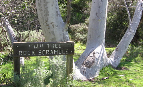 Keep running along the Canyon View Trail past the Cerro Este Road on your left. Keep moving forward until you meet up with Ohlone Camp Road and keep running past the "W" Tree rock scramble on your left. This is something I will come back to do. It is a true rock scramble (narrow boulder pile) all the way up the side of this grade. Keep in mind that the trails that are labeled as "roads" are not paved roads, except for Welch Creek Rd. That may be a no brainer for some, but I thought it was worth mentioning. All of the trails labeled "road" are fire roads at best and two tracks at worst. Run along the Ohlone Camp road for another quarter mile until you come upon a gate. Turn left up the hill and now you are on Back Pack Road.
 Back Pack Road ends your gentle rolling run along the riverbanks and quickly restarts your climbing. From here on the vista views just get better and better. The climbing is steep and it may force you to walk a bit. It may even sound torturous but believe me when I tell you, it is worth every step you struggle to take. The views looking back over the Calaveras Reservoir are incredible. Looking to the right side of the reservoir you will see the super popular Mission Peak. Turn back around and look up the hill and just imagine how much better the views are going to get! That will inspire you to keep moving up the hill. Back Pack road will dead end at McCorkle Trail. Turn left and head uphill towards the Cerro Estes overlook. At the McCorkle/ Cerro Este split choose the right, uphill path and continue upwards on the Cerro Este road. Not far up this trail you will want to take the trail on the left called Cave Rocks Road toward the Eagle View trail. Cows are all over this area and they love to just stare at you. One particular big boy was on the edge of the trail and I wondered what my infant son would think of this big beast if he saw it up close and personal. The fun of this section does not last long as this short trail section is about 6/10ths of a mile long and then Eagle View trail comes up on the right.
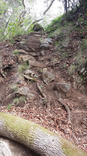 Eagle View trail is completely different then any other trail up to this point in the run. It starts with a tree canopy over a narrow single track that is covered in rocks, roots and trail debris. To me this was a welcome change of pace from the almost road like running I had mostly done so far. The super cluttered trail quickly gives way to a fast single track still under the tree canopy. Not far into the trail the route turns up a set of steep stairs and runs under the canopy for just a short way. When the trail comes back out into the open it seems to narrow. The upside hill is super steep on your right and the downhill is just as steep on your left. Parts of the trail are eroded away and you are really high up on this hillside. The view is perhaps the best of the run. The danger heightens your senses and the run gets that much more awesome. All in all Eagle View trail only lasts for about a mile. When the trail splits you can go either way. Both routes will dump you out onto Welch Creek Rd.
 |
| Rock Climbers can be seen all over the park. |
This is an incredibly difficult run but I cant wait to do it again. I can not recommend this park enough. The park is in the middle of nowhere, way off the beaten path and yet it is full. You might have to search a bit to find a parking space. That's a testament to just how great this park is. If you haven't been, go.
No comments:
Post a Comment
Give us your 2 cents!!!