 |
| Bobcat @ Russian Ridge OSP |
These attacks are extremely rare, see here.
If you do encounter a big cat make yourself as large as possible. Stand tall and place small children on your shoulders but do not squat down to pick them up. Make noise. Do not turn from them. Do not run away. SLOWLY back away while looking and sounding as large and fearless as possible. I have ran for countless hours through these hills and have NEVER seen a big cat. You do not need to be so afraid that you refuse to enter the woods. That is an over reaction. Go into the trails 1 hour after sunrise and stay on the trails until 1 hour before sunset. Dusk and dawn are active feeding, moving times. While in the woods I recommend you randomly clear your throat loudly or clap your hands to make a little extra noise to let the world know you are out there.
Bay Area "Loops"
- Bay Area Ridge Trail- AKA "The dirt one"- A series of inter-connecting trails that will someday wrap all the way around the bay. Currently large portions of the trail are missing but large portions of the trail are connected through the Santa Cruz mountains.
- Bay Trail- AKA "The paved one"- A series of inter-connecting bike paths that will someday wrap all the way around the shoreline of the bay. Currently large portions of the path are missing but large portions of the path are connected through San Mateo County, Santa Clara County & Alameda County.
- My article on The Bay Area Waterfalls
Check out this list of Bay Area Summits
This is a list of named summits in the nine-county San Francisco Bay Area that are more than 1,000 feet (305 m) above sea level.
Golden Gate National Recreation Area
Golden Gate National Recreation Area (GGNRA) chronicles two hundred years of history, from the Native American culture, the Spanish Empire frontier and the Mexican Republic, to maritime history, the California Gold Rush, the evolution of American coastal fortifications, and the growth of urban San Francisco.- GGNRA Overview map and info
- Golden Gate Park overview map.
- Marin Headlands
- Fort Mason
- Phleger Estate- enter from Huddart Park
- Muir Woods
- Crissy Fields
- Lands End
- Interactive GGNRA Map

Marin County Parks & Open Space Maps
Mid peninsula Regional Open Space District Maps
Of the District's 26 preserves, ranging from 55 to nearly 17,000 acres, 24 are open to the public free of charge, 365 days a year from dawn until one-half hour after sunset.
|
|
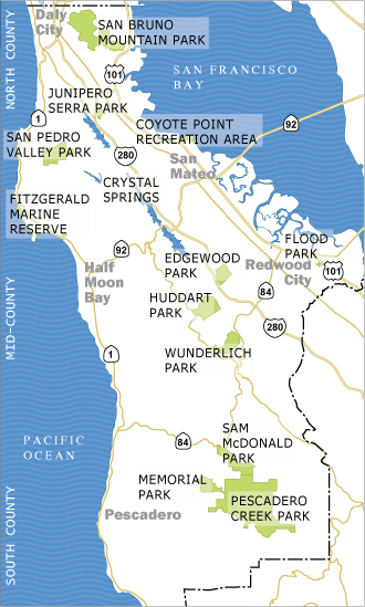
The Parks Department operates 17 separate parks in a wide variety of natural
settings including a coastside marine reserve, a bayside recreational area,
coastal mountain woodland areas, and urban sites. Enjoy the rich and diverse natural spaces the San Francisco Peninsula has to
offer by utilizing the San Mateo County Trails. There are 186 miles of trails to meet
your recreational needs. Explore the scenic Pacific Coast. Climb to stunning
views above the Bay. Nestle through the dense forests of the Santa Cruz
Mountains. Or cruise alongside the sparkling lakes of the San Francisco
Watershed.
Santa Clara County Parks
Santa Clara
County acquired its first parkland in 1924, purchasing 400 acres near Cupertino
which became Stevens Creek
County Park. In 1956, the Department of Parks and Recreation was formed.
Currently, the regional parks system has expanded to 28 parks encompassing
nearly 45,000 acres.
Saratoga City Trail Maps
East Bay Regional Parks
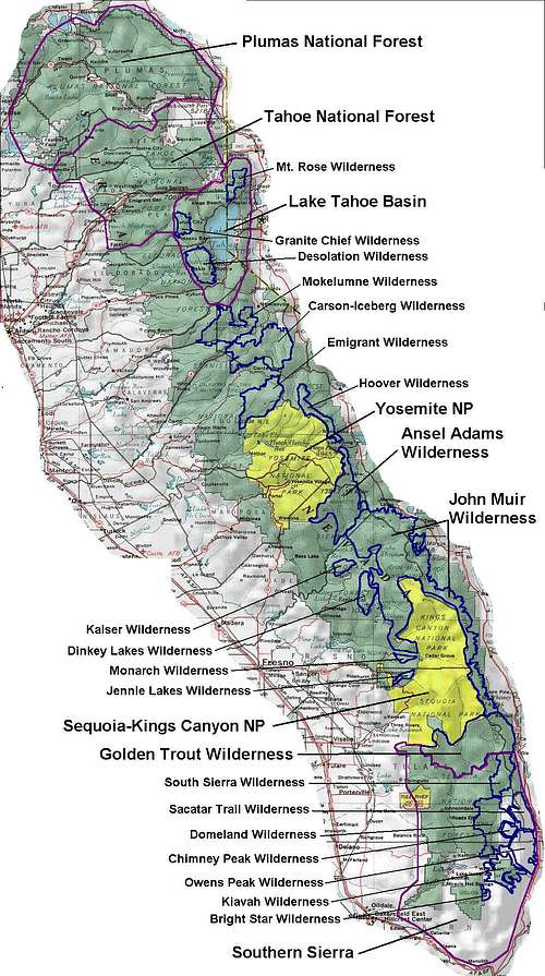
State Parks & Trails
- Angel Island Perimeter Trail- 5 mi- Access to the island is from private boat or public ferry from San Francisco, Tiburon or Vallejo. There is NO weekday ferry service to Angel Island during the winter.
- China Camp Shoreline Trail- 3 mi- The Shoreline trail is a 1.5 mile trail that is very popular with hikers and cyclists alike. The trail itself is fairly level making it ideal for all levels of hiking fitness.
- Mt Tamalpias State Park- More than 50 miles of trail are within the park and connect to a larger, 200-mile-long trail system. Runners are challenged by the twisting road to the top of the park's summit.
- Mt Diablo State Park- View the stars from its lofty heights, bike ride to its 3,849 foot summit or explore the more remote trails by horseback. The park offers hiking, biking, horseback riding and camping.
- Ano Nuevo State Park- Between Half Moon Bay & Santa Cruz
- Big Basin Redwoods State Park- California's oldest state park, established in 1902, has grown to more than 18,000 acres, with over 80 miles of trails passing among streams, waterfalls, and old-growth redwoods.
- Butano State Park- The park is on the San Mateo Coast, off Highway One. Three miles northeast of the Gazos Creek Coastal Access Point by way of Gazos Creek Road, and about 4.5 miles southeast of Pescadero by way of the Pescadero and Cloverdale Roads.
- Castle Rock State Park- The forest here is lush and mossy, crisscrossed by 32 miles of hiking and horseback riding trails. These trails are part of an even more extensive trail system that links the Santa Clara and San Lorenzo valleys with Castle Rock State Park, Big Basin Redwoods State Park, and the Pacific Coast.
- Portola Redwoods State Park- This state park is covered by Douglas fir, oaks, and giant coast redwoods, one of which, at 300 feet in height, is among the tallest in the Santa Cruz Mountains.
National Park Service Trails
-
Juan Bautista de Anza National Historic Trail- Spanish Lt. Colonel Juan Bautista de Anza in 1775-76 led more than 240 men, women and children on an overland journey across the frontier of New Spain to settle Alta California. Follow 1200 miles in the footsteps of this intrepid, multiethnic expedition, and explore the rich cultural history of communities from Nogales, Arizona, to San Francisco.
- Pacific Crest Trail- Zigzagging its way from Mexico to Canada through California, Oregon and Washington the Pacific Crest Trail (PCT) boasts the greatest elevation changes of any of America's National Scenic Trails, allowing it to pass through six out of seven of North America's ecozones including high and low desert, old-growth forest and alpine country.
No comments:
Post a Comment
Give us your 2 cents!!!